Toronto's New Transit Map
 A tourist on the subway once asked me where Kensington Market was on the subway map. I pointed to a vacuous black hole on the sparse map, and the tourist was placated, but definitely still confused. I don't blame her. Our current subway map — featuring four colored lines in a sea of blackness — doesn't say much about our transit system, much less our city.
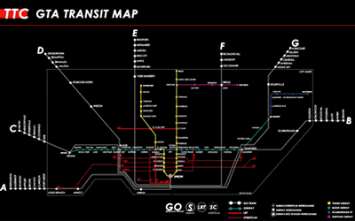
Graeme Stewart over on Reading Toronto has come up with a concept map that meshes subway, GO Train, LRT, and streetcar routes in Toronto, to show the true network of our city. In his post accompanying the maps, Stewart explains the importance of having a highly connected transit conception for the city:
Connectivity is the real success of Toronto’s system. Streetcar exchanges at Broadview and St. Clair West, and GO transfers at Kipling and Dundas West are examples of what makes the system work. Most transit riders don’t use the subway in isolation, but transfer between multiple modes. Yet finding the best rout is often a matter of trial and error; a trade secret among experienced riders. Clearly illustrating the connections within the network would show the extensiveness of the system we already have, and hint at the areas best suited for future expansion.While the map itself offers a positive marketing opportunity for the city, pitching Toronto as being highly networked and accessible, it also can serve as an impetus for a new conception of the city by residents. It can expand the traditional limits of where people actually "go" in the city, bringing an awareness of of the diverse and vibrant neighborhoods in the city limits, and will help to instill an increasing pride in our transit system, and subsequently, Toronto itself.
posted by Sameer Vasta at 8:05 AM
![]()


2 Comments:
Roland Barthes wrote that the Eiffel Tower is a sign whose meaning derives in part from its place in the system of signs made up of all the tall towers in the world.
Marc Auge, in his 'In the Metro', discusses how the meanings of different sites in the city are felt and experienced while riding on particular metro lines and disembarking at particular stops.
The map/logo of a subway system, when compared with all the others--London, Paris, NYC, Tokyo--can be an object of identification more intimate and powerful than many others. One might even say that what the flag is to the nation the subway map can be to the city. (I bet London sells as many tube map T-shirts as they do Union Jacks--okay, maybe not quite.)
If you can find a place that sells a T shirt with the TTC map of today, let me know. After looking at these maps, I couldn't help but think that the ordinary one which we see day in and day out does have a certain character. It's not just that it's humble; it's sort of, well, retro.
Now there's a title for an ethnography of the Toronto subway: 'In the Retro'.
no t-shirts that i know of, but you can still get the buttons!
Post a Comment
<< Home