Saturday, May 27, 2006

Congress 2006 @ York University

The 75th Congress of the Humanities and Social Sciences kicks off this week at York University. The theme is "The City: A Festival of Knowledge", and the week-long event (May 27-June 3) includes many sessions of note for those interested in urban issues. A quick glance at the program reveals sessions with titles such as "Ethnography and Urban Culture" and "Practicing Memory in the City" (both May 30, organized by the Canadian Sociology and Anthropology Association); and "Imagining the Theatrical City" (May 27). Numerous associations participate in the Congress; check out each association's program here. Other highlights include concerts, art exhibits and guest speakers such as Stephen Lewis and David Suzuki. The array of activities really leaves no choice but to descend upon York and be festive.

Friday, May 26, 2006

New Book: Belfast: Segregation, Violence and the City

My friend Jaap in Leiden, the Netherlands, has drawn my attention to a new book that seems to follow in the tradition of Allen Feldmans's early-1990s classic about violence in Ireland, "Formations of Violence." Here is the blurb:

"Paris, Jerusalem and Belfast are cities that are shaped by political
violence, death and the injustices caused by segregated living. But divided
cities are becoming places within which policy makers and politicians
project an image of normality despite the facts of social injustice,
victimhood and harm.

It is a commonly held view that the city of Belfast is emerging out of
conflict and into a new era of tolerance and transformation. This book
challenges this viewpoint. The authors pinpoint how international peace
accords, such as the Belfast Agreement, are gradually eroded as conflict
shifts into a stale and repetitive pattern of ethnically-divided competition
over resources. This book also offers new material on politically motivated
violence in Belfast through the use of mapping and other statistical
techniques.

Belfast offers a vivid portrait of how segregation, lived experience and
fear are linked in a manner that undermines democratic accountability. The
authors argue that the control of place remains the most important weapon in
the politicisation of communities and the reproduction of political
violence. Segregation provides the laboratory within which sectarianism
continues to grow. Examining the implications of these social divisions, the
authors draw upon a wide international literature and provide insights that
will be useful to students of geography, planning, politics, sociology and
peace studies."

Tuesday, May 16, 2006

New Waterfront Designs Unveiled

Cross-posted from blogTO:

As part of an effort to get Toronto residents engaged in the future of the city's waterfront, the Toronto Waterfront Revitalization Corporation is launching an Innovative Design Competition where global design firms will publicly display their concept designs for the public. Five design teams have been short-listed for the competition, and will exhibit their plans for our waterfront from today until May 26, 2006 at various shopping centres across the city.

More information on blogTO.

Sunday, May 14, 2006

Film on NYC March for Immigration Reform

Truthout.org has a great short video report on the recent march for immigration reform in NYC. It looks like it was a fun time. The film is called New York City: Mayday Immigration Protest and Boycott. It's by Sari Gelzer. Follow the link and scroll down.


Thursday, May 11, 2006

China Building Eco-City

According to the Guardian, China has decided to build an eco-city that will be globally unparalleled. From the Guardian article:
Pollution-free buses, ­powered by fuel cells, run between neighbourhoods. An intranet service forecasts travel times and connects people who want to share a car. ­Traditional motorbikes are for­bidden, replaced by ­electric scooters or ­bicycles. The roads are laid out so that walking or cycling to work is quicker than ­driving.
If it already sounds like a utopian dream, you should see what else they have planned for Dongtan, the world's first purpose-built eco-city at the mouth of the Yangtse River.

Spacing Wire also has a post on the project, and what it may mean on a global scale.

Wednesday, May 10, 2006

Unforeseen by Theory


Mike Davis, uber-urbanist, sums up his take on globalization and urbanism in an interview at Tomdispatch: "Stunningly enough, classical social theory, whether Marx, Weber, or even Cold War modernization theory, none of it anticipated what's happened to the city over the last 30 or 40 years. None of it anticipated the emergence of a huge class, mainly of the young, who live in cities, have no formal connection with the world economy, and no chance of ever having such a connection. This informal working class isn't the lumpenproletariat of Karl Marx and it isn't the "slum of hope," as imagined 20 or 30 years ago, filled with people who will eventually climb into the formal economy. Dumped into the peripheries of cities, usually with little access to the traditional culture of those cities, this informal global working class represents an unprecedented development, unforeseen by theory."

There's much more in this interview: about L.A., the riots, San Diego, Marxism, militarization, gangs, and the culture of American fear. Definitely worth a read. (picture from the geography dept at Berkeley).

Tuesday, May 09, 2006

Rising Sea Levels - Interesting Google Hack

Picked this up off the Boing Boing site.

Interactive maps show your city's floodline when the sea rises

By Cory Doctorow
Cory Doctorow: This Google Maps hack shows you how your city will fare as the world's oceans rise -- how much will be underwater as the sea rises to different depths. Pictured here, Lower Manhattan at 7m. Link (via Kottke)

I tried zooming in to get a look at Toronto specifically but to no avail.

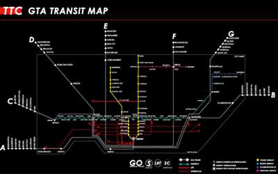
Toronto's New Transit Map

Graeme Stewart's Proposed Transit MapA tourist on the subway once asked me where Kensington Market was on the subway map. I pointed to a vacuous black hole on the sparse map, and the tourist was placated, but definitely still confused. I don't blame her. Our current subway map — featuring four colored lines in a sea of blackness — doesn't say much about our transit system, much less our city.

Graeme Stewart over on Reading Toronto has come up with a concept map that meshes subway, GO Train, LRT, and streetcar routes in Toronto, to show the true network of our city. In his post accompanying the maps, Stewart explains the importance of having a highly connected transit conception for the city:
Connectivity is the real success of Toronto’s system. Streetcar exchanges at Broadview and St. Clair West, and GO transfers at Kipling and Dundas West are examples of what makes the system work. Most transit riders don’t use the subway in isolation, but transfer between multiple modes. Yet finding the best rout is often a matter of trial and error; a trade secret among experienced riders. Clearly illustrating the connections within the network would show the extensiveness of the system we already have, and hint at the areas best suited for future expansion.
While the map itself offers a positive marketing opportunity for the city, pitching Toronto as being highly networked and accessible, it also can serve as an impetus for a new conception of the city by residents. It can expand the traditional limits of where people actually "go" in the city, bringing an awareness of of the diverse and vibrant neighborhoods in the city limits, and will help to instill an increasing pride in our transit system, and subsequently, Toronto itself.